About
We are a group of professionals in the field of planetary science and exploration who are passionate about maps and democratising planetary mapping on the web.
How it started
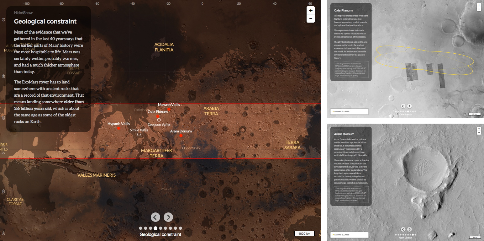
The OpenPlanetaryMap project started off in 2015 as an ESAC’s trainee project in collaboration with CARTO to build an interactive map of the ExoMars 2020 rover landing sites. The “Where On Mars?” interactive map was designed as a storymap guiding people through the main scientific and engineering constraints for the selection of the ExoMars 2020 rover landing site. It lets you explore Mars and each candidate landing site.
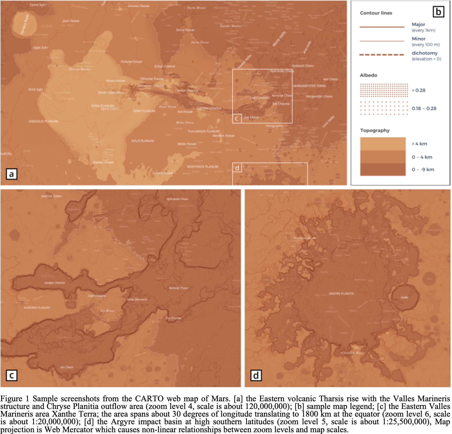
The success of the “Where On Mars?” interactive map encouraged us to build something more ambitious: an Open Planetary Mapping platform that would enable people to easily share location-based knowledge and create maps of planets and moons in our solar system. Thanks to the Europlanet’s Public Engagement Funding Scheme in 2017, we managed to make some progress towards this goal. Our main focus was on designing high-quality basemaps for Mars and the Moon that are engaging for the broader public, yet scientifically rigorous. This work lead to the publication of the “Towards a new face for Planetary Maps” paper and the OPM Mars basemap v0.2 XYZ map tiles.
Building on the success of our Mars basemap, we learned that delivering a full Open Planetary Mapping platform is a larger, longer-term effort than we could complete at the time. That original vision remains our north star, and it now shapes a more concrete roadmap for what comes next.
What’s next?
We are seeking an institutional partner to help us secure the long-term availability of our basemaps. We also intend to improve our current basemaps for Mars and the Moon, and expand to other planetary bodies such Mercury, Venus, and the Jovian moons. In particular, we would like to provide vector tiles and map styles based on an “open planetary layers schema” similarly to the OpenMapTiles schema for OpenStreetMap layers.
Contributors
- Nicolas Manaud
- Angelo Pio Rossi
- Trent Hare
- Stephan van Gasselt
- Andrea Nass
References
- Nass, A., Manaud, N., van Gasselt, S., & Hare, T. M. (2019). Towards a new face for Planetary Maps: Design and web-based Implementation of Planetary Basemaps. Advances in Cartography and GIScience of the ICA, 1, 1–8. https://doi.org/10.5194/ica-adv-1-15-2019 [PDF]
- Manaud, N, Nass, A., Lewando, M., van Gasselt, S., Rossi, A. P., Hare, T., Carter, J., & Hargitai, H. (2018). OpenPlanetaryMap: Building the first Open Planetary Mapping and Social platform for researchers, educators, storytellers, and the general public. EPSC2018-78. https://ui.adsabs.harvard.edu/abs/2018EPSC...12...78M
- Manaud, N., Boix, O., Vago, J., Hill, A.; Iriberri, C., Carrión, D. (2015) “Where On Mars?”: A Web Map Visualisation of the ExoMars 2018 Rover Candidate Landing Sites. EPSC2015-228. https://ui.adsabs.harvard.edu/abs/2015EPSC...10..228M